Line Choices

Every mountain biker understands that line choice is essential to riding smoothly. The difference of a good line and bad line determines whether you can maintain speed in the best case. In the worst case, it determines whether you get through a section or whether you slow down, stop, or even crash. This is why every basic mountain biking tutorial stresses the importance of looking ahead and scanning the terrain.

As with most things, this is easier said than done. It requires plenty of practice. Line choice is not much of an issue on even terrain or at low speed. It becomes important when you go fast and it becomes much more challenging when you ride trails with many obstacles. High speed and gnarly trails in combination present a challenge even to expert riders.

mountain_bike_trail_line_choice

So, what exactly goes on when you pick a line? You look at the trail ahead and you are presented with choices. The farther you look ahead, the more information you have to process, but on the positive side, more information allows you to make better decisions. Let’s look at an example to illustrate this.

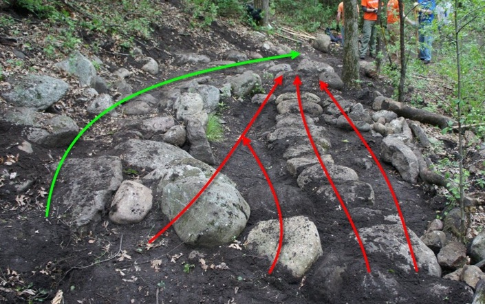
Say you are going down a hill on a rutted trail and you scan ahead 10 metres. There’s a rut running on left, so you decide to stay on the right side. Then you look 20 metres ahead instead of ten. You realise the trail makes a right turn and that the rut deepens further down, so you will be cut off from the berm on the left rim of the turn.

Staying on the right, you won’t be able to pass through the curve while maintaining speed. You will have to brake and ride the early apex line which is slow. With farther range scanning, you decide to hop over the rut early and take the berm line which is fast. The rut on the left is the lesser evil in this case.

Now, let’s look at what is going on in your mind, when picking a line. In plain language, there is A (a good line) and B (not a good line). Logically speaking, A is not B and therefore by choosing A you will avoid B. One might conclude that by avoiding B, one would end up riding an A line. Unfortunately, this is not the case.

In reality, these are two different modes of thinking that yield very different results. If you think A, you make an acceptance decision. Chances are that you clear the section smoothly. If you think not-B, you make an avoidance decision. This means you have to change course and reevaluate. The reevaluation costs you time, therefore you have to slow down. Even worse, it might be followed by yet another avoidance decision.

The not-B thinking mode leads to choppy riding, accompanied by line switching and unnecessary braking. What is more, by looking at obstacles for too long, the bike might just follow the line of vision and run straight into them, since steering always follows the line of vision. The A thinking mode leads to fluent riding, less corrections, and reduced braking. When you commit to a line, no further time is wasted with evaluation.

It’s quite important to develop an awareness for these two different states when riding. Whenever you notice that avoidance decisions outnumber acceptance decisions, you have reached a critical point where the trail works you instead of you working the trail. It happened to me often enough, and I found there is only one way to deal with it.

You have to stop, and sort of force a mental reset. It’s like flipping a switch. The mantra is: “I see a line. There’s nothing but a line.” So, the solution for getting out of the avoidance mode that bumps you around the trail is to move the focus away from obstacles towards non-obstacles, or rather small obstacles you are willing to take on. It sounds very simple and straightforward, but applying it in practice is a different story.

2015 Burning Season Starts

The air quality has started to decline once again in Chiang Mai and the first fires of the season are observed. Last weekend, seven riders rode the jungle trail in the valley north of the Huay Jo reservoir in Maejo and went right through a bushfire.

The fire was very likely laid by mushroom gatherers. It is sad to see this particular valley burning because unlike the higher degraded regions around Huay Jo that have been reforested recently, this part of the forest is more intact and has richer soil.

The smoke of these fires does not only cause havoc to people’s health, but it is also very damaging to the forest. The fire kills small plants, saplings, and a host of small animals like reptiles, amphibians, small mammals, and their hatcheries, thereby reducing biodiversity and giving an advantage to pests and invasive species. It also prevents the buildup of a rich humus layer.

Since it is impossible to catch the arsonists, the only viable measure seems to outlaw mushroom gathering. The arsonists only need a few seconds to light a fire, but the gatherers spend many hours/days in the forest and are easy to catch.

DSC_0270 DSC_0271

21 December 2014: Maejo MTB Race

It’s the season of MTB races, apparently. There’s one more this Sunday starting at 10:00 AM at the Mae Jo scout camp near Huay Jo which is quite familiar territory to many of you who have joined our rides. Check out http://www.thaimtb.com/forum/viewtopic.php?f=54&t=1114680 for details. We meet at 8:30 AM at the camp (18.934786, 99.061136) and figure out where the trail runs and whether we want to participate or squander the starting fee on pizza and ice cream while cheering the other riders. Either way, it’s going to be fun. We do suspect that you need a roadworthy mountain bike for this race, although having seen previous Thai mountain bike races, anything with two wheels and a crank will do, whether thin or fat tyres, curly or straight bars, as long as you can ride it.

This ride is cancelled.

6 December 2014: Long Downhill from Doi Pui to Mae Raem

It’s time for another Doi Pui ride! This is probably the longest route down the mountain. It starts at the San Koo drop off point from where we ride down to the sala, climb to the Doi Pui peak, then ride the northern ridge, ride down to Khun Chang Khian and then take the northern route to Mae Raem which is a little less steep than the one to Huay Tueng Tao. After an optional stopover at the Sala Café, we will ride back to Huay Tueng Tao along the single track trail west of the military base. We meet at 8:30 AM at the parking lot at the Huay Kaeow arboretum (18.810537, 98.949085) and take a Songthaeo to get up the hill. You need a capable mountain bike for this trip. Estimated duration is 5 hrs.

ridge-route

22 November 2014: Mae Ho Phra Race Course

mae-ho-phra-race

This Saturday, we go to explore a new route in Mae Ho Phra that is new to (at least most of) us. We meet at 8:00 AM at the entry gates of Maejo university (18.89506, 99.009378). There we will try to catch a Songthaeow going up north along the Rd. 1001 Phrao Rd. Depending on the success of this mission, we will be at the intersection of the Rs. 1001 with the new Rd. 1414 (extension of Rd. 1095) in Mae Faek around 9:00 AM, or later if we have to ride the distance. From there, we proceed approx. 5 km to the Mae Ho Phra district administration on Rd. 1001, which is where the XC race course starts. The course lies northwest of the Ban Na Pak reservoir and is only a few km long, which means we will probably ride more than one lap. Including the time for getting to and back from the race course from Chiang Mai, we estimate this ride to take 5 hrs or more.

Ride Report

Three riders met on a beautiful and slightly chilly Saturday morning. Two of us rode up from Chiang Mai to Mae Ho Phra where we met a third rider at Rd. 1001. After five more kilometres and a cup of coffee, we hit the trails. The marking of the course is less than obvious, so we missed the correct turns several times. The landscape is gently undulating and the track is technically easy apart from short technical zig-zag sections at the beginning/end near the temple. It’s mostly gravel and loose dirt plus some sandpits to slow things down. We finished the actual course before noon and did some practice riding along the technical sections afterwards. These require bursts of power and correct gearing to master. I finished around 1:00 PM and caught a taxi back to Chiang Mai.

15 November 2014: Bamboo DH Trail

We meet at 8:00 AM at the parking lot at the Huay Kaeow arboretum (18.810537, 98.949085). We will arrange transport by Songthaeo to the helicopter landing place just below Pu Phing Palace. For those who prefer to climb the hill, we expect to be at the landing place around 8:45. This is a short (6.5 km) but challenging DH trail with steep sections and plenty of roots, ruts, and rocks. Pads are recommended.

bamboo-trail-map

Ride Report

Five riders met on Saturday. Three of us took a taxi to meet Tim and Ong at the top. After some warmup, we began the riding down the Bamboo trail at 9:15 AM. Trail conditions were quite good. The trail is dry and fast now, but the rainy season left its mark in the form of additional ruts. Some of these rutted areas have new side lines. In the lower section, there are many loose rocks. We finished the downhill run at 10:20 AM. Tim and I decided to hike back up for some extended riding. Tim turned around at 650m altitude and I went up to 900m to shoot some more GoPro footage. I finished the second run at 13:15 PM.

DSC_0084 DSC_0086

8 November 2014: Maejo Ramble

We meet at 8:00 AM at the entry gates of the Mae Jo university in Nong Han (18.89506, 99.009378). From there, we take small country roads and dirt tracks to the Huay Jo reservoir. This area has a wide network of cross country trails, mostly gravel and dirt, so we will decide on the spot which one we take. Some options are the jungle single track loop, the ridge line east of the reservoir, or the Maejo farm race course. We can also combine several trails. Depending on which option we choose, the difficulty level is easy to medium with some minor climbs. Most likely to be completed before noon (=less than 4 hours).

maejo-race-course

I started from the university at 8:10 AM and went to “the square”, then on to the trails leading to Huay Jo. Instead of going to the reservoir, I decided to follow the ridge trail west of the reservoir that climbs to about 650m, which is as high as it gets in this area. I reached the farthest point around 10:00 AM, where the trail turns into narrow single track winding steeply down to the valley behind the lake. It’s not very rideable, so I turned around and followed the gravel path into the valley. This was a lot of fun to ride, although very loose. I reached the lake at 10:50 AM and after a brief rest at the sala decided to return home.

DSC_0059 DSC_0070 DSC_0081

1 November 2014: Mon Cham – Rocktower View Point

It’s November and it’s officially winter. Let’s begin the new month with a ride that combines three things, a hard climb, beautiful views, and an exciting downhill section. We meet at 8:00 AM in Don Kaeo at the end of the canal  Rd. 121 (18.867118, 98.959848). From there, we ride north to Mae Rim, where we turn east Samoeng Rd. 1096. We follow this road until Pong Yaeng and then take the steep country road that leads up to Mon Cham. After an (optional) break at the Mon Cham coffee shop, we continue our ride on forest tracks until we get to the Kin Long viewpoint, also known as “rocktower cliff”, where we stop over. Since this is the highest point of Mae Rim (1400m), it’s all downhill from there. We take the fire road that leads down to Mae Raem (approx. 12 km) through dense forest. This trip requires a mountain bike. Total distance is approx. 55 km, there are ca. 1200m climb; estimated duration is 7 hours including breaks.

mon-cham-loop

Ride Report

No takers on Saturday. I left the meeting point at 8:15 AM and reached Pong Yaeng at 9:30 AM. Had a break at the coffee shop before climbing up the road to Nong Hoi. The climb was quite a slog as expected, but conditions were ideal as it was dry and cloudy. I reached the Mon Cham restaurant at 11:00 AM and had some food there. Then I moved on the the Kin Long viewpoint, another 150m climb. I really love this place, so I spent at least half an hour at the peak. At 12:45 PM, I started heading back via the double track forest path leading down to Mae Raem. This trail is in a terrible condition with unbelievably deep ruts. It can only be negotiated by  MTB or enduro motorcycle. There is a difference between a technically challenging trail and plainly hazardous trail and this one falls into the latter category. The lower sections are quite overgrown with bamboo and I had to get off the bike often. I reached Mae Raem at 14:15 PM, and think I will look for an alternative way down the hill when going to Mon Cham next time.

I noticed a great amount of dead/run-over snakes this time, mostly juveniles. Must have been a dozen or more. Never saw that many.

DSC_0024 DSC_0031 DSC_0036 DSC_0041 DSC_0051

26 October 2014: New Lake DH Ride

On Sunday, we meet at 8:00 AM at the parking lot at the Huay Kaeow arboretum (18.810537, 98.949085) and arrange taxi transport to the San Koo drop off point on the top of the mountain. We ride down to Khun Chang Khian and take the New Lake route from there. This is a not-too-difficult single track trail through forested area which we first rode in the rainy season in August. We have several options for descending further to Huay Tueng Tao or to other exits which we will decide on the spot. The trail is partly steep and stony in some places, but does not require advanced technical skills. Estimated duration is 4 hours including taxi shuttle and breaks. Can take longer if we decide to take detours.

new-lake-route

Ride Report

Four participants met on Huay Kaeow road. We took a Songthaeo to San Koo as planned and started the ride just before 9:00 AM. The first third of the route up to the Khun Chang Khian Hmong village was cool, shady, and slightly damp. After a short break at the village, we continued on the forest trail leading northeast which was also damp and a bit slippery in some places. This trail offers many nice views, so we stopped here and there to take pictures. When we reached an elevation of about 900m, the the dirt tracks in the orchards became much drier. After another 350m descent, we reached the lower part of the Eagle’s route. We took the single track short cuts on the right side of the road and then the trail leading to the cascades above the lake. We reached Huay Tueng Tao at approx. 11:00 AM.

DSC_0055   new-lake-02DSC_0059DSC_0073DSC_0074